Here we are in the middle of December and from all reports, the weather gods have decided to be nice to the Rocky Mountain west and hammer the eastern seaboard instead. Fine with me! It meant that I could con my riding buddie, Eddie (actually his name is Dave, but I call him Eddie — from American Flyer fame) into joining me for a quick spin.
Today was about the best one could expect for this time of year. It was hovering around 40 degrees F and if there was a breeze, it was very faint and out of the east. Our quest today was to ride a route that was to avoid chip-seal. We both HATE chip-seal!!!
We rode east out from Eddie’s house on Cty Rd 4 and turned south on Cty Rd 21 and headed into Boulder County. The latter stretch is rather ‘V’ shaped with a drop down to the Little Thompson River (more like a creek!) and then climbs back up to the intersection with Yellowstone Rd. We jogged east to pick up the road that leads to Hover and turned west onto some gorgeous, brand new pavement on Woodland. This was a short, flat stretch that was felt like it had zero rolling resistence! A very pleasant change from the chip-seal we’ve been riding in Larmier County whenever we ride north.
I’ve thoroughly enjoyed the track, but I must say it was nice to get out and ride on the road again. We rode south to CO 66. This was the second time I’ve been on the road and the first for Eddie since they replaced the asphalt with grooved concrete. I’m not a fan of grooved concrete (in my car or on my bike) but it wasn’t better than I expected and the new bike lane was HUGE! I am a fan of safety and wide bike lanes on major roads. They really did a nice job in that area. Turning north where the Old Prague Inn used to be (kinda feel like I’m back in New England where you tell folks to hang a left where the old church used to be…) More brand new asphalt — all the way home! Out of the 16.8 miles we rode, I’d say about 15 miles of it was brand new asphalt. Ahhhhhhhh.
Without a doubt, we met our goal with flying colors! By virtue of the quality of the pavement, this could become one of our favorite close-to-home routes.
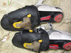
Success does not come without challenges however. Today, the challenge was walking down Eddie’s and my own snow-packed (and melting!) country driveways with my Look cleats on. As you can see in the photo, these cleats are not designed with snow-shoeing in mind. When we started out, I had to do a stomp-dance for a couple minutes to get the cleats clear. Same thing when I got home (as you can see below).

Hazard of riding in the Winter!
Today I rode with the Garmin Edge 305. Of course, I forgot to start the timer until half way thru the ride. Good thing I also use a Vetta C16 for my trip time/distance info since that doesn’t require me to manually start and stop it!
Vetta C16 Data:
Distance: 16.8 miles
Ride Time: 1:12:12
Ave Speed: 13.9 mph
Max Speed: 30.5 mph
Garmin Edge 305 Data:
Distance: 9.29 miles
Ride Time: 42:46
Elevation Gain: 238 ft , Loss: 283 ft (basically a FLAT ride!)
Ave Speed: 13.0 mph
Max Speed: 30.7 mph
Ave HR: 115 bpm
Calories: 450
